Written by Sunil Kumar Pariyar and Noel Keenlyside, this post offers a closer look at central drivers of weather and climate patterns and their ties to extreme weather events in the Pacific Islands region.

On April 13, 2015, tropical cyclone PAM hit Vanuatu (a Pacific Island country) with a devastating speed of 250km/hour. This category five cyclone caused significant damage across five provinces of Vanuatu and affected approximately 188,000 people; of which 11 people lost their lives, and around 65,000 became homeless. Remarkably, as shown by the satellite image (Figure 1), PAM was connected to three other major tropical cyclones around Australia and the northwestern Pacific. Climate scientists have never observed such an occurrence of four tropical cyclones together within one week and later found that this unique incidence was associated with a tropical phenomenon called the Madden-Jullian Oscillation (MJO). It is well known to the scientific community that the MJO can influence the number and intensity of the tropical cyclones, but this particular case of four tropical cyclones was a rare event and hence left a message of how vital the MJO is for this region.
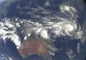
Figure 1
To understand the MJO and its impacts, we must turn to rainfall. The rainfall over the tropics is quite variable in both space and time. A unique feature of this region is the organization of the rainfall to very large scales. In the annual mean, there are two major rain bands: one that extends across the equatorial North Pacific and another that occupies the South Pacific. These rain bands make the western Pacific habitable. However, these rain bands do change their location and strength in different seasons and years. The El Niño phenomenon is the most well-known factor affecting them, and during El Niño, these rain bands shift eastward and can cause drought condition lasting several months. This tends to occur every few years.
In the South Pacific, there are also episodic wet and dry weather conditions in the sub-seasonal period that last for one to two weeks and occur roughly every 30 to 80 days. The MJO is the main factor causing these sub-seasonal variations in rainfall. This phenomenon was discovered in the early 1970s by Roland Madden and Paul Julian, hence its name. The MJO is a moving rainfall system that usually develops over the Indian Ocean and gradually moves to the eastern Pacific through the Maritime Continent and western Pacific. As it moves east, it brings strong winds, heavy clouds, and thunderstorm with heavy rainfall.
Fair, dry, and relatively warm weather are usual before these windy and rainy episodes. This cycle of calm and then stormy weather occurs roughly every 30 to 80 days. In meteorology, the cloudy and rainy events are termed as an active stage, whereas the calm and dry episodes are known as the suppressed stage of the MJO. The wet and dry episodes of MJO are well known for their impact on the timing and strength of Indian, East Asian, and Australian Monsoons. Similarly, the tropical cyclone activity is also significantly affected by the MJO over the northwestern Pacific and South Pacific.
Climate scientists consider MJO as one of the primary factors causing sub-seasonal rainfall variations over the western Pacific. Therefore, it is vital for the weather and climate of the Pacific island countries. In particular, extremely dry and wet conditions associated with the MJO can have severe impacts on the Pacific island communities with limited water management infrastructures. Therefore, accurate prediction of the rainfall can be very useful in this region.
In recent years, the prediction of sub-seasonal climate has gained tremendous attention in the scientific community, because of its potential to predict extreme weather and climate events. Successful prediction of extreme events on these timescales can facilitate the development of an early warning system to improve societal preparedness and reduce the potential impacts. The sub-seasonal climate prediction usually defined as the time ranging from two weeks to two months fulfills the gap between short-term weather forecast (five to seven days) and long-term climate prediction (seasonal, annual and decadal). Sub-seasonal climate prediction aims to forecast climate and such things like the chances of extreme weather events 20 to 60 days in advance.
Significant scientific efforts are being made to better understand and predict the MJO and its impacts on global weather and climate. Several national and international weather and climate agencies provide useful information about the current MJO condition and its future evolution along with the potential regional impacts in different parts of the tropical Indo-Pacific region. The local authorities from small island countries can benefit from such information and implement them in creating awareness to the general public so that any potential impacts can be reduced. Some useful links regarding the current status of the MJO and future prediction relevant for the Pacific island countries are provided in the reference list below. Additionally, some useful documents and links to the website where more information about the MJO and its global impacts can be found are also provided for further reading.
References
- Pariyar, S. K., Keenlyside, N., Bhatt, B. C., & Omrani, N. E. (2019). The dominant patterns of intra-seasonal rainfall variability in May-October and November-April over the Tropical Western Pacific. Monthly Weather Review, (2019). https://journals.ametsoc.org/doi/pdf/10.1175/MWR-D-18-0383.1.
- Madden, R. A., & Julian, P. R. (1971). Detection of a 40–50 day oscillation in the zonal wind in the tropical Pacific. Journal of the atmospheric sciences, 28(5), 702-708. https://journals.ametsoc.org/doi/abs/10.1175/1520-0469(1971)028%3C0702:DOADOI%3E2.0.CO;2.
- Madden, R. A., & Julian, P. R. (1972). Description of global-scale circulation cells in the tropics with a 40–50 day period. Journal of the atmospheric sciences, 29(6), 1109-1123. https://journals.ametsoc.org/doi/abs/10.1175/1520-0469(1972)029%3C1109%3ADOGSCC%3E2.0.CO%3B2.
- Vitart, F., & Robertson, A. W. (2018). The intraseasonal to seasonal prediction project (S2S) and the prediction of extreme events. npj Climate and Atmospheric Science, 1(1), 3. https://www.nature.com/articles/s41612-018-0013-0.pdf
- Tropical Cyclone Pam: Lessons learned workshop report, June, 2015. https://www.spc.int/sites/default/files/wordpresscontent/wp-content/uploads/2016/12/TC-Pam-Lessons-Learned-Report.pdf
- Chand, S. S., & Walsh, K. J. (2010). The influence of the Madden–Julian oscillation on tropical cyclone activity in the Fiji region. Journal of Climate, 23(4), 868-886. https://journals.ametsoc.org/doi/full/10.1175/2009JCLI3316.1.
- Australian Bureau of Meteorology, MJO monitoring: http://www.bom.gov.au/climate/mjo/.
- National Weather Service, Climate Prediction Center, NOAA: https://www.cpc.ncep.noaa.gov/products/precip/Cwlink/MJO/mjo.shtml.
- National Institute of Water and Atmosphere Research (NIWA) – Island Climate Update: https://www.niwa.co.nz/node/111123.
- What is the Madden-Julian Oscillation? https://www.metoffice.gov.uk/weather/learn-about/weather/atmosphere/madden-julian-oscillation.
- Meet the MJO https://wwa.colorado.edu/climate/iwcs/archive/IWCS_2008_May_focus.pdf.
- What is the MJO, and why do we care? https://www.climate.gov/news-features/blogs/enso/what-mjo-and-why-do-we-care.
 Sunil Kumar Pariyar is a Ph.D. student at the Geophysical Institute, University of Bergen, Norway. His Ph.D. research focuses on the sub-seasonal rainfall variations over the western Pacific

Noel Keenlyside is a Professor of Meteorology and Climate at the same institute. His research interests include tropical climate variations and prediction